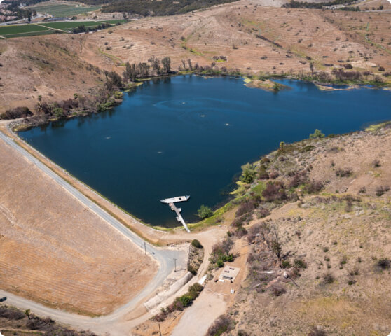
The Syphon Reservoir improvement project is an investment to increase the capacity of the existing Syphon Reservoir, which is part of our recycled water system.
The Syphon Reservoir Improvement Project is an investment to increase the current Syphon Reservoir storage capacity from 578 acre-feet to 5,000 acre-feet (from 188.3 million gallons to 1.6 billion gallons).
By doing so, we can store more recycled water to meet seasonal and future needs. This will reduce our dependence on costly imported water and make our community more self-sufficient.
IRWD has a longstanding and ongoing commitment to transparency. We welcome neighbors and community members to share their questions and comments about the project at info@IRWD.com, or sign up for updates on the project.
Project start
Design phase
Construction phase
Estimated project completion
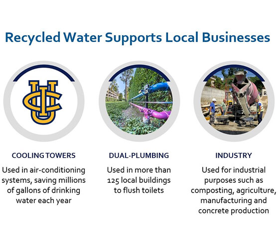
Recycled water is an abundant, affordable, and reliable part of Irvine Ranch Water District’s diverse water supply portfolio. We have one of the most robust and technologically advanced recycled water systems in the nation, which helps us meet the water needs of our community while responsibly preparing for the future.
To learn more about IRWD’s innovative recycled water system, visit our recycled water webpage.
The Syphon Reservoir Improvement Project will modernize and upgrade the existing recycled water reservoir so it continues to meet or exceed the latest federal and state safety standards. The proposed project will be peer reviewed through a rigorous process overseen by a technical advisory group made up of respected engineers and safety experts.
IRWD has established an Independent Design & Safety Review Panel of nationally recognized dam industry experts. The Review Panel will provide an objective, third-party peer review of the design, engineering and safety of IRWD’s Syphon Reservoir Improvement Project. This independent panel of experienced professionals will confirm that state and federal design standards have been met and that the project meets IRWD’s high standards for quality and community safety.
Lelio Mejia, PhD, PE, NAE – Senior Principal Engineer, GeoSyntec Consultants, Oakland
More than 40 years of experience in geotechnical and earthquake engineering for 25+ large earth dams. Design and construction of more than 15 major dam projects worldwide. Contributor to advancing the state of practice for seismic analysis and earthquake loading criteria for the safe design of dams throughout the US, including consultation for the state Division of Safety of Dams. Chair of the United States Society on Dams (USSD) Earthquakes Committee; Member of the International Commission on Large Dams Committee on Seismic Aspects of Dam Design; Member of the National Research Council (NRC) Committee for the State of the Art and Practice in Earthquake Induced Soil Liquefaction Assessment. Ph.D., Geotechnical Earthquake Engineering, University of California, Berkeley; M.S., Geotechnical Engineering, University of California, Berkeley; B.S., Civil Engineering, Universidad Javeriana, Bogota, Colombia.
Faiz Makdisi, PhD, PE, D.GE – Senior Consultant, Gannett Fleming, Sacramento
(Geotechnical, Seismic, Geology)
Forty-five years of experience in geotechnical and civil engineering. Directly involved in applied research and analysis of foundation/earthquake engineering and safety evaluations of earth-fill and rock-fill dams. Member of the U.S. Bureau of Reclamation Board of Consultants for Conconully and El Vado Dams. Performed Federal Energy Regulatory Commission (FERC) safety inspections and facilitated safety inspections for more than 80 dams. Facilitated dam risk and safety workshops for more than 40 dams. Ph.D., Geotechnical and Geoenvironmental Engineering, University of California, Berkeley; M.S., Geotechnical and Geoenvironmental Engineering, University of California, Berkeley; B.E., Civil Engineering, American University of Beirut, Lebanon.
Dan Hertel, PE – Co-Founder, Engineering Solutions, Denver
(Construction/Cost Estimating)
More than 37 years of experience in the construction of dams, pipelines and tunnels. Expertise encompasses risk assessments, constructability analysis and review, and construction sequencing for safe and proper execution of large dams. Member of Association of State Dam Safety Officials and past President of USSD. B.S., Construction Engineering, Montana State University.
John Trojanowski, PE – Trojanowski Dam Engineering, Denver
(Hydraulic Structures, Risk-Informed Decision-Making, USBR- Retired)
More than 42 years of engineering experience related to dams and waterways. 37 years with the Bureau of Reclamation’s Dam Safety Program and Retired Manager of the Waterways and Concrete Dam Group. Facilitated and participated in numerous risk analyses and dam safety advisory groups for the Bureau of Reclamation, U.S. Army Corps of Engineers, California Department of Water Resources, and other agencies. B.S., Civil Engineering, University of Colorado at Boulder.
Brett Sanders, PhD – Professor, Civil and Environmental Engineering, University of California, Irvine
(Civil, Downstream Hydrology/Flooding)
Researcher specializing in information technologies to create more accurate and efficient simulation tools, flooding and erosion hazards and urban flooding. Expert in surface water quality, low-impact development impacts on hydrology, dam-break flooding, aerial and terrestrial lidar scanning and geographical information systems. Interim Associate Dean for Undergraduate Student Affairs. Ph.D. Civil Engineering, University of Michigan; M.S. Civil Engineering, University of Michigan; B.S., Civil Engineering, University of California, Berkeley.
By clicking Sign Up you’re confirming that you agree with our Privacy Policy